The Nazca Lines are so impressive that some believe they were created by extraterrestrials. Although science has proven that it was the work of the Nazca and Paracas cultures, the mystery remains:
How did they manage to align figures with millimetric precision in such a vast desert, creating 93-meter hummingbirds and 110-meter monkeys that can only be appreciated from the air? Today I take you to know the history, theories and secrets that keep the Nazca Lines as one of the greatest enigmas in the world.
What are the Nazca Lines?
The Nazca Lines are more than 700 enormous drawings of zoomorphic, anthropomorphic and geometric figures traced in the desert of the southern coast of Peru. These figures represent animals, plants and abstract shapes so large that they can only be fully appreciated from the air, covering an area of approximately 500 km².
Among the best known figures are the monkey, the orca, the condor, the hummingbird, the pelican, the spider, flowers and trees.
The ancient inhabitants of the Nazca culture, who inhabited this region between 100 B.C. and 700 A.D., created most of these figures between 500 B.C. and 500 A.D. However, recent research has revealed older geoglyphs, attributed to the Paracas culture, consisting mainly of human figures.
Despite advances in research, the Nazca Lines remain a mystery. From ground level, it is impossible to appreciate their full shape, which has led some researchers to consider that they may have served as sacred pathways used in rituals.
In 1994, UNESCO declared the Nazca Lines a World Heritage Site, recognizing their cultural and archaeological importance.
How were they made?
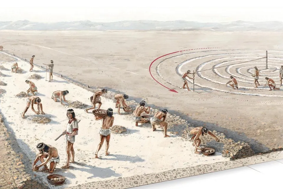
The Nazca created the lines by removing the dark stones and pebbles from the desert, exposing the lighter soil beneath. This process, known as depressions, generated negative images that, thanks to the desert climate and gentle winds, have been preserved for centuries.
Recent studies indicate that there are two phases in the creation of these lines:
- Paracas Phase (400 to 200 B.C.)
- Nazca Phase (200 to 500 A.D.)
This confirms that the Paracas culture was the first to create geoglyphs in the region, although it was the Nazca culture that perfected and expanded these designs.
Most of the lines are straight and cross the landscape for several kilometers, while others form designs of animals and geometric figures that have become recognizable symbols of the Nazca culture.
Why haven't the Nazca Lines been erased?
The Nazca carefully removed 10 to 15 cm of the topsoil, composed of reddish-brown ferric oxide-coated stones, exposing a yellowish-gray inner layer with a high lime content.
They used rudimentary surveying tools, such as wooden stakes to mark the beginning and end of the lines, as demonstrated by carbon dating tests conducted at the site.
The climate of the Nazca desert has been key to the preservation of the lines. The region is extremely dry, with stable temperatures and very little rainfall, ideal conditions for preventing erosion.
The morning humidity and lime content of the soil helped to harden the surface, creating a protective layer that has resisted the winds and kept the figures intact for more than 1,500 years.
However, in recent decades, climatic changes and the presence of squatters since 2012 have begun to deteriorate some of the lines, posing a challenge to their conservation.
Why are you considered a Nazca mystery?
The Nazca Lines are considered one of the greatest archaeological mysteries in the world because, to this day, it is not known with certainty the purpose for which they were created or how they managed to make them with such precision more than 1,500 years ago.
The Nazca culture left no written records or clear clues as to their function, and the lines can only be fully appreciated from a great height, a concept that seems inexplicable considering that aviation did not exist at that time.
This enigma has given rise to numerous theories, from those suggesting that the lines were astronomical calendars or water maps, to those proposing that they were sacred paths used in fertility and water rituals.
The fact that they have remained intact for so long, combining mystery and accuracy, continues to fascinate travelers, researchers and archaeologists around the world.
History
Who discovered the Nazca Lines?
The first mention of the Nazca Lines appears in the book Crónicas del Perú by Pedro Cieza de León in 1553. There, he described them as “trail markers” on the Nazca plains that resembled roads.
Pedro Cieza de León, a Spanish chronicler who arrived in Peru after the news of the discovery of Tahuantinsuyo, traveled the Peruvian coast, highlands and jungle during the conquest.
In his book, he mentioned that while traveling along the coast, he observed straight and extensive lines in the pampas, but he did not describe animal figures. This is probably because, although some lines are visible from the nearby hills, to appreciate the complete figures it is necessary to observe them from the air.
In 1569, Luis Monzon also reported seeing ruins in Peru, including “remains of roads in the sand,” although at the time no one gave them any importance.
Centuries passed before the lines received attention again, because they can only be appreciated in their magnitude from the air, although some are partially visible from the hills. The first modern reports emerged in the 20th century, when Peruvian military and civilian pilots spotted them during flights in the area.
This interest caught the attention of Peruvian archaeologist Toribio Mejia Xesspe, who in 1927 spotted the lines while walking in the hills during fieldwork. Although he had a limited view, he recognized that they were not simple trails and began to study them. In 1939, he presented his findings at a conference in Lima, putting the Nazca Lines on the archaeological map and attracting the attention of researchers and historians.
First in-depth studies
However, it was the American historian Paul Kosok who became the first scholar to study them in depth. Kosok arrived in Peru in 1940 to investigate ancient irrigation systems, but after hearing about the lines, he decided to fly over the area and observed that some were bird-shaped.
This discovery completely changed his research, as he realized that the lines were not random paths, but something deeper, perhaps art or coded messages. As he walked near them, he noticed that some lines converged on the horizon during the winter solstice in the southern hemisphere, which reinforced his interest.
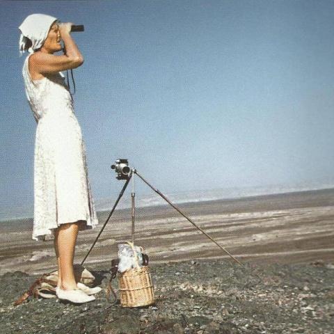
Kosok abandoned his initial research on irrigation canals and devoted himself to studying the Nazca Lines in depth, fascinated to discover their purpose. He was joined in his research by American archaeologist Richard P. Schaedel and German mathematician and archaeologist Maria Reiche.
This team determined how the lines were made, although the great unknown remains as to what they were made for. One of their most relevant theories holds that the lines functioned as astronomical markers indicating the rising of the sun and other celestial bodies on significant dates, becoming an astronomical calendar based on the constellations of the night sky.
Kosok described the 310-square-mile Nazca desert as “the world's largest astronomy book,” while Maria Reiche dedicated her life, over 40 years, to the study and protection of the lines, becoming the “Lady of the Lines.” In 1974, she received a grant from National Geographic to continue her research, convinced that the lines had an astronomical and calendrical purpose.
Maria Reiche even lived in a small house near the desert to personally protect the lines from unwise visitors.
|
Before establishing their astronomical theory, this team considered that the lines might have been ceremonial routes or even offerings to the gods.
However, in 1967, American astrophysicist Gerald Hawkins conducted studies that found no correlation between the celestial bodies and the design of the lines, thus disproving the astronomical calendar theory.
New discoveries
In 2011, a team from Yamagata University, Japan, discovered two new figures: one in the shape of a human head, possibly from the early Nazca or Paracas culture, and another in the shape of an animal, whose age is still unknown. This team, which had been researching in the area since 2003, announced in 2012 the discovery of 100 new geoglyphs in the Nazca region.
Their work was recognized by Smithsonian magazine due to the identification of birds represented in the geoglyphs. Although the figures were thought to correspond to native birds, the Japanese researchers discovered that many represented exotic birds from non-desert habitats, raising new questions about their meaning.
In 2020, using drones, they discovered the figure of a cat on a steeply sloping hill that, because it was exposed to erosion, had gone unnoticed for centuries. Thanks to this technology, new sites of research interest have been identified.
Currently, the number of geoglyphs in Nazca has risen to 358 and the existence of more figures in the future is not ruled out.
In 2024, with the assistance of artificial intelligence, a team of archaeologists from Yamagata University, in collaboration with IBM Research, discovered 303 new geoglyphs, including figures of parrots, cats, monkeys, killer whales and even severed heads, near the world-famous Nazca Lines.
These discoveries demonstrate that the Nazca Lines continue to offer new mysteries and insights into the ancient cultures of Peru, keeping the intrigue of researchers and travelers from around the world alive.
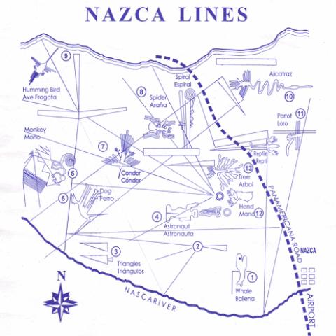
Figures of the Nazca Lines
Currently, more than 700 figures have been discovered in the Nazca Lines, of which 300 are geometric figures and about 70 represent animals distributed throughout the desert.
Some geoglyphs stand out for their design, size and history, becoming representative symbols of this enigmatic archaeological site. Here are the most important figures:
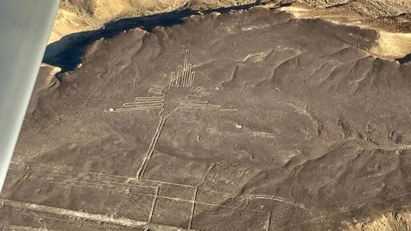
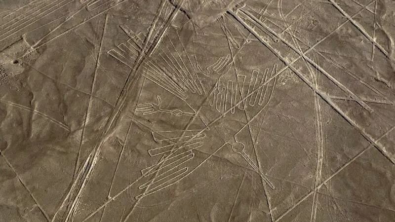
The Hummingbird
Approximately 93 meters long, it is one of the most iconic figures of Nazca, standing out for its detail and delicate geometric design that shapes a hummingbird with great precision.
Hummingbirds are associated with water and fertility in many South American civilizations, which would explain their presence at Nazca, where there are more than 125 species of hummingbirds in Peru.
Archaeologist Maria Rostorowski stated that this geoglyph represented an important deity or flying god, respected and feared by the Nazca population.
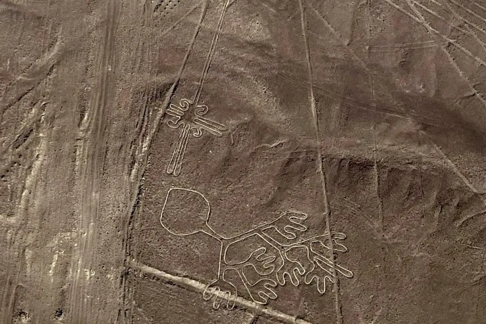
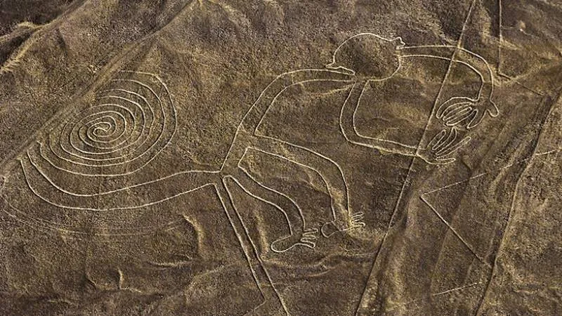
The Monkey
It is approximately 110 meters long and is characterized by its spiral tail and its design with nine toes, which generates intrigue as to how the Nazca culture could create such precise figures without an aerial perspective.
This animal, characteristic of the jungle and not the desert, could symbolize fertility or water, crucial elements for Nazca life. Its existence demonstrates that the Nazca had a wide knowledge of the fauna of Peru.
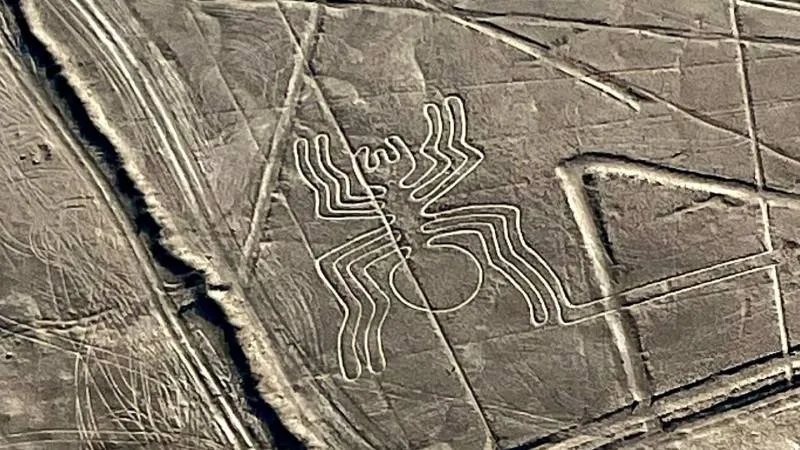
The Spider
With 47 meters long, the spider presents a detailed design with its eight long legs, making it one of the most defined geoglyphs and easy to distinguish from the air.
Some researchers argue that it may represent the constellation Orion and that it is linked to water, as the webs collect morning dew.
This was one of the first geoglyphs sighted by Paul Kosok.
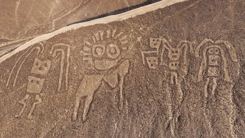
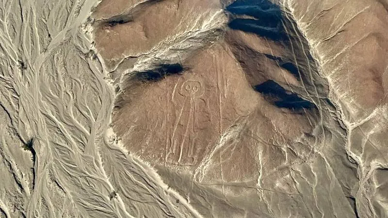
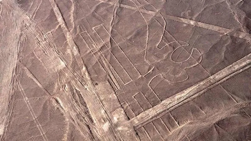
The Astronaut
This 30-meter-high figure stands on a hillside and shows a humanoid with one arm raised, as if waving to those watching from the air.
People call it “the Astronaut” for its appearance, which fuels theories about extraterrestrials, although some argue that it could be a shaman, priest, or even a fisherman because it seems to hold a net in its left hand.
Researchers believe that this figure could be one of the oldest and possibly attribute it to the Paracas culture.
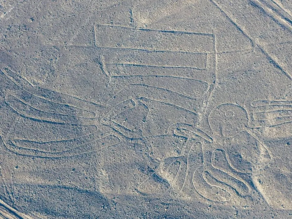
The Pelican
Also known as alcatraz or flamingo, this geoglyph is 290 meters long, making it one of the largest in Nazca.
It represents a pelican with a winged body and a long zigzag neck ending in a stylized head. In spite of being difficult to distinguish, its large size facilitates its identification during overflights.
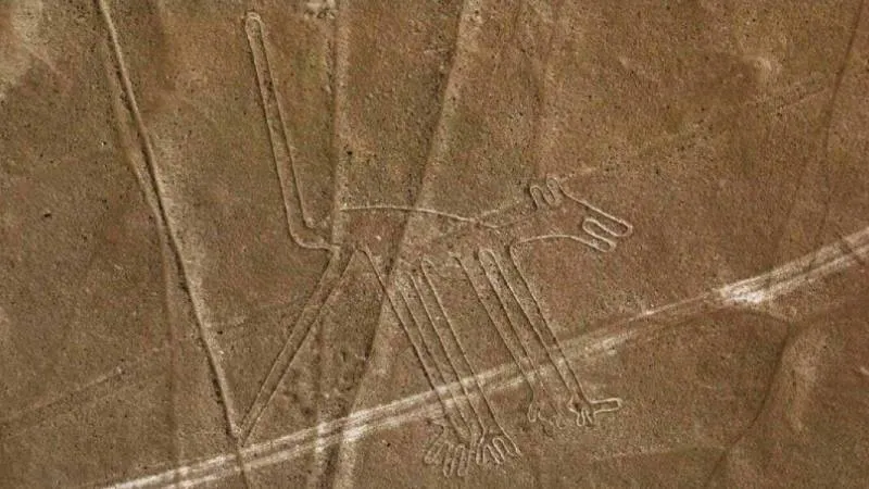
The dog
This geoglyph is 51 meters long and represents a dog with an upright posture, pointed ears, open eyes and mouth, as if it were alert.
It possibly symbolizes loyalty and companionship, values associated with dogs in many South American cultures. It is believed to represent a Peruvian dog, according to the characteristics observed in the figure.
The whale
At 65 meters long, this figure represents a whale, although some researchers maintain that it is a killer whale.
Its presence demonstrates the Nazca's relationship with the Pacific Ocean and their knowledge of marine fauna, despite living in a desert region. This geoglyph is an example of how the Nazca used the desert as a canvas for their art, instead of ceramics or textiles like other cultures.
The Condor
This 134 meter long geoglyph shows a condor with outstretched wings and is one of the most prized Nazca geoglyphs. The condor has a deep spiritual significance in South American cultures, as it was believed to transmit messages between the earthly and divine worlds. Some researchers argue that it could represent a chaucato (long-tailed nightingale), although others defend its identification as a condor because of its symbolism in the Andean cosmovision.
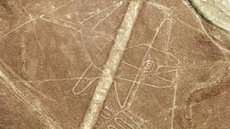
The parrot
With 200 meters of extension, it is one of the biggest figures of Nazca. The presence of a non-local bird raises questions about possible commercial links of the Nazca with people of the jungle or expeditions carried out by this culture.
Although it is difficult to detect due to the multiple lines that cross the area, upon close observation it is possible to identify its head, large crest and beak.
The beak of this figure points directly towards the sunrise during the month of June.
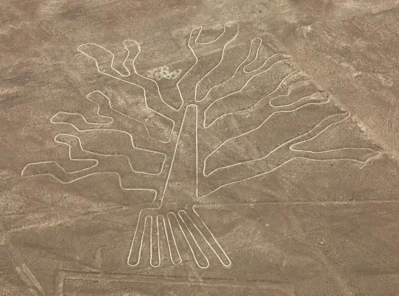
The Tree
This geoglyph represents a tree with a central trunk and elongated branches that open at the top, while its roots extend downward.
Approximately 70 meters long, it is visible from the lookout tower located on the Panamerican Highway South, near the figure of Las Manos.
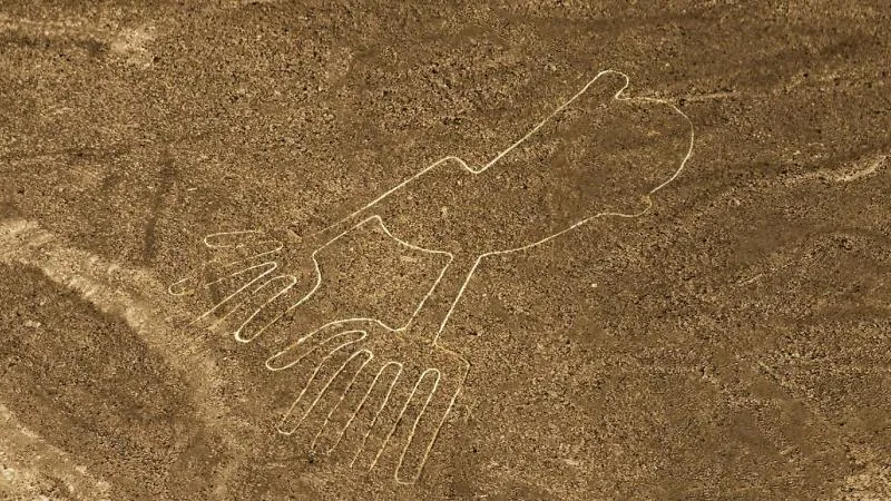
The Hands
It represents two extended hands, similar to those of the monkey geoglyph. The right hand has five fingers, while the left one has only four, generating intrigue about the absence or retraction of the thumb.
It has an approximate size of 50 meters and is also visible from the lookout tower.
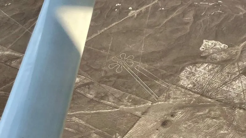
The flower
This figure represents a flower with a long stem and seven petals extended symmetrically, with an approximate diameter of 40 meters. This figure sits in an area far from the lookout towers, so visitors can see it only during overflights.
The new lines
In 2024, researchers using artificial intelligence discovered 140 new Nazca lines, increasing the unknowns about their meaning and conservation. Several of these figures can be visualized through Google Maps, although not all of them are clearly distinguishable.
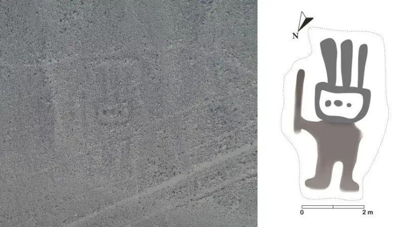
The Humanoid
This figure measures approximately 2 meters wide and 4 meters high, being one of the smallest and most enigmatic.
It represents a humanoid with a scepter in its hand and a three-pointed headdress on its rectangular head. Its identification was complex even for the AI due to its degree of deterioration.
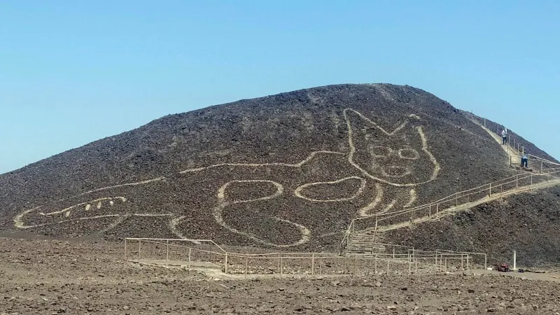
The cat
Researchers recently discovered this 31-meter-long figure next to the stairs of a Nazca lookout point, and it represents a feline with pointed ears, round eyes, a long striped tail, and an open mouth, as if it were surprised.
Its design is similar to the felines represented in ceramics and textiles of the Nazca culture. Carbon 14 dating studies indicate an antiquity between 200 and 100 B.C., which makes it one of the oldest figures in the area.
Theories about the Nazca Lines: Why were they created?
Scholars know with certainty that the Nazca people created these lines, but they still debate their true purpose. Thanks to the investigations carried out during decades, several theories have emerged, some of them with solid foundations and archaeological findings.
Here we present the most outstanding theories:
Astronomical Calendar Theory
The Kosok-Reiche theory holds that the Nazca Lines functioned as a huge astronomical calendar for observing the sky. According to this hypothesis, the straight lines and figures marked the rising and setting of the sun, moon and important stars on specific dates of the year, such as the solstices, helping the Nazca to plan planting and harvesting.
Paul Kosok was one of the precursors of this theory, calling the Nazca desert “the largest calendar in the world”. His successor, Maria Reiche, continued this research, confirming his observations and defending this theory for more than 40 years, which earned her the nickname “The Lady of the Lines” by the Peruvian government and UNESCO.
- Authors: Paul Kosok and Maria Reiche.
Julio César Tello's Theory
Julio César Tello, considered the father of Peruvian archaeology, proposed that the Nazca Lines had an origin and purpose linked to the Paracas culture, prior to the Nazca.
According to Tello, people used the lines and figures as sacred roads during religious ceremonies and pilgrimage processions dedicated to the worship of nature gods. This theory is based on the similarities Tello found between the lines and ancient pre-Hispanic roads near Paracas cemeteries, as well as their location near burial sites and hills used as places of worship.
Markus Reindel and Johny Isla's Theory
Markus Reindel (German archaeologist) and Johny Isla (Peruvian archaeologist) have been investigating the Nazca Lines since the 1990s through systematic excavations.
Reindel and Isla concluded that the Nazca people performed rituals linked to water and the fertility of the land, which were fundamental for their survival in a desert environment. The Nazca used the lines as ceremonial spaces to perform rituals related to underground water sources and sacred mountains.
Archaeologists support this theory with findings of offerings such as ceramic fragments, textiles and wooden rods in the middle of the geoglyphs, as well as the location of lines pointing to sacred hills and water sources instead of celestial bodies.
Water and Fertility Rituals
Another theory suggests that the lines were related to water, a vital resource in the Nazca desert. The Nazca may have created these figures to ask for rain from their gods and fertility for their crops. Researchers believe that people walked on the lines in processions and rituals to invoke rain and give thanks for the crops.
The Nazca may have used figures of birds, monkeys, and whales as totems linked to their mythology or as symbols to honor the gods of the sky and mountains.
You can go deeper into this theory in the book “The Nasca Lines: A New Perspective on Their Origin and Meanings”, supported by Anthony Aveni, former National Geographic scholar.
- Author: Johan Reinhard (1943).
Donald Proulx's Theory
Archaeologist Donald Proulx and hydrogeologist Stephen Mabee proposed that the Nazca lines indicated different sources and supplies of groundwater.
The presence of Puquios, hydraulic systems constructed near the lines to extract water from underground aquifers, supports their theory and demonstrates the advanced hydraulic engineering of the Nazca.
Irrigation System Theory
Paul Kosok initially proposed this little-known theory before developing his astronomical calendar theory. He suggested that the lines were part of a large-scale irrigation system to collect and distribute water in the desert.
Although Kosok abandoned this hypothesis, some researchers continue to debate this possibility, considering the Nazca's skill in constructing subway aqueducts.
Theories about extraterrestrials and ancient astronauts
Some people argue that visitors from other planets created the Nazca Lines as signals for spacecraft, because the figures have a gigantic size and can only be fully appreciated from the air.
The Swiss Erich von Däniken is the greatest defender of this theory and in his book “Chariots of the Gods” (1968) he affirms that the lines would be landing strips for extraterrestrial ships, based on the figure of the “Astronaut”.
However, there is no scientific evidence to support this theory, and most archaeologists reject the relation of the lines with extraterrestrials.
What archaeologists say today?
Today, most archaeologists agree that the Nazca Lines represent a combination of astronomical calendar, water rituals and symbols important to the Nazca cosmovision.
The Nazca had a deep knowledge of their environment, the climate and the skies, and used these lines as part of their rituals and to strengthen their connection with their gods.
Bottom line:
- Nazca lines were messages on the ground for their gods and for their community.
- They helped mark when to plant and when to expect rain.
- They also served as sacred paths that people walked along during ceremonies to ask for water and fertility for the land.
Thus, although we still need to uncover some mysteries, the Nazca Lines reveal how this ancient culture used art, astronomy, and nature to connect their spirituality with the world around them.
How to see the Nazca Lines
Flying over the Nazca Lines
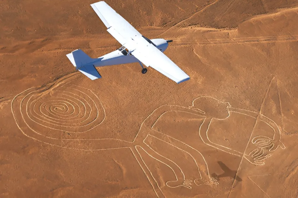
The best way to appreciate the Nazca Lines is from the air, aboard tourist planes that offer panoramic flights or from a lookout point on the Panamerican Highway South.
From the sky, you will be able to clearly observe the animal figures and the straight lines that cross the desert, revealing designs of hundreds of meters with perfect shapes that have remained intact for thousands of years.
The flight lasts approximately 30 minutes and includes a bilingual guide who will point out the most important figures while explaining their history and significance. You can book flights in the morning or afternoon with your group of friends, as the planes offer varying capacities depending on the number of passengers.
At first glance, the lines may appear to be simple faint markings from the viewpoints, but as you fly over them you will discover the magnitude and precision of these enigmatic geoglyphs.
Average flight price:
- Between $70 and $110 per person.
If you suffer from vertigo or prefer not to fly, you can also enjoy the Nazca Lines from the following viewpoints.
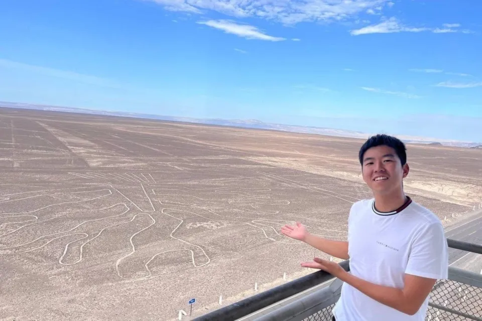
Lookout Tower
Located near the Panamericana Sur highway, this tower offers an elevated platform 13 meters high from where you can observe some of the closest figures, such as The Tree, The Hands and the Lizard, as well as several straight lines that run along the Nazca pampas.
Although you will not be able to see all the majestic figures from this tower, it offers an excellent economic and accessible alternative to admire part of this World Heritage Site.
Location: 20 km / 12 miles north of the city of Nazca, with direct access from the Pan-American Highway.
Entrance fees:
- National and foreign adults: 6 soles.
- University and technical students: 2 soles.
- Minors and school children: 1 sol.
Is it worth flying over the Lines?
Yes, it is totally worth it to fly over the Nazca Lines. You can truly appreciate their size, complexity, and beauty only when you see them from the air, since from the ground you perceive them merely as scattered lines.
The experience of seeing them from the sky is unique, impressive and will allow you to understand why these figures remain one of the greatest mysteries of mankind.
If you want to make the most of your visit, we recommend that you make the flight early in the morning, when the winds are lighter and the weather is more stable.
Your trip with Ultimate Trekking
If you want to make this experience without worries, in Ultimate Trekking we offer you the Peru Highlights & Short Inca Trail package (12 days and 11 nights), where we take you to know the most emblematic destinations of Peru:
✨ Lima, Pisco, Huacachina, Paracas, Cusco, Sacred Valley, Short Inca Trail, Machu Picchu, Vinicunca Rainbow Mountain, the southern route of Cusco, Puno and Lake Titicaca.
We include the experience of flying over the Nazca Lines so you can admire these wonders with specialized guides, safety and comfort, integrating this stop within a complete trip that will connect you with the history, culture and nature of Peru.
Where are the Nazca Lines?
The Nazca Lines are located in the Nazca desert, in the department of Ica, southern Peru. These enigmatic figures extend over more than 500 km² and are located approximately 7 hours by car from Lima.
How to get to the Nazca Lines?
The easiest route to get there is by land from Lima along the Panamerican Highway South. Although Nazca has a small airport, it receives very few flights and there are no regular commercial flights from Lima.
Provincial bus
From Lima, you can take an interprovincial bus to Nazca at the city's bus terminal. The trip takes between 6 and 7 hours and some of the recommended companies are Cruz del Sur, Oltursa, Soyuz and Civa.
- Approximate price: 90 soles (16 USD).
Private car
Another comfortable option is to hire a private transportation service, which will allow you to travel at your own pace along the Panamericana Sur and make stops in Pisco or Ica before continuing on to Nazca.
One of the advantages of this option is that you can make a stop at the famous Huacachina Oasis, just 1.5 hours from Lima, to enjoy the dunes before continuing your trip.
Flight
There are no regular commercial flights from Lima to Nazca, but some private agencies offer charter flights that last approximately 1 hour.
- Approximate cost: 500 USD per person.
Guided tour
The most practical way to visit the Nazca Lines is to hire a guided tour with a travel agency. They take care of the logistics, transfers at the best times and the purchase of tickets, allowing you to enjoy this impressive cultural heritage without worries.
Climate
Nazca has a warm and dry climate throughout the year, with almost no rainfall. It has two seasons:
- Summer (December to March): Daytime temperatures of up to 32 °C (90 °F).
- Winter (May to September): Maximum temperatures of 27 °C, with cool nights of up to 13 °C.
The Humboldt Current and the El Niño oscillation regulate coastal temperatures, keeping them stable and favoring the preservation of the lines due to low rainfall and minimum humidity.
Best time to visit the Nazca Lines
Thanks to Nazca's stable climate, you can visit them at any time of the year. However, the high season is from December to March, when there is less fog, clear skies and more heat, which allows better visibility of the lines from the air and optimal conditions for tourist flights.
What else to see in Nazca?
Nazca is not only mysterious lines, it also offers museums, archaeological sites and unique experiences that will help you understand the greatness of this culture.
Maria Reiche Museum
This small museum pays tribute to the work of Maria Reiche, the Peruvian-born German mathematician who dedicated her life to the study of the Nazca Lines.
Here you can see maps, diagrams, photographs, artifacts, a model of the lines and personal objects of Maria Reiche. The museum is located very close to the observation tower, so you can take advantage of your visit to see it.
- Admission fee: 5 soles
- Hours: Every day from 8:00 a.m. to 6:00 p.m.
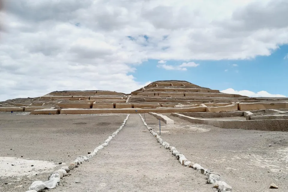
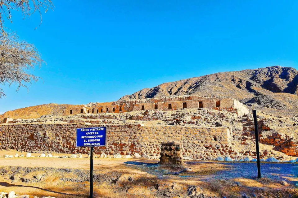
Cahuachi
Cahuachi was a pre-Columbian ceremonial center active between 1 AD and 500 AD. Artifacts were found here confirming that it was a place of pilgrimage and ceremonies.
Its importance diminished after the decline of the Nazca culture in 300 AD. The highlight of the site is its large adobe pyramid, 150 meters long and 28 meters high, along with natural mounds topped with adobe structures.
- It is located 24 km from Nazca, in the Cahuide area.
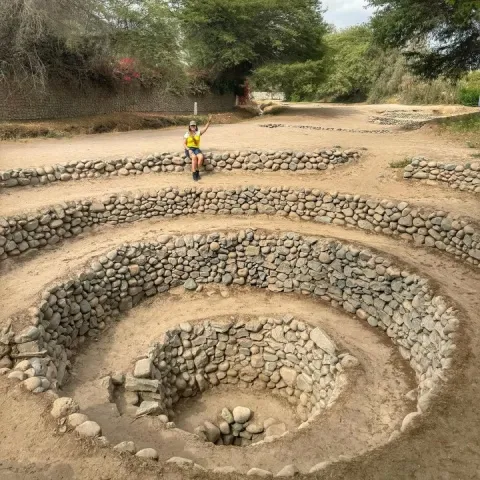
Cantalloc Aqueducts
These aqueducts are an example of the Nazca's ingenuity in hydraulic engineering, allowing them to prosper in an arid environment.
They served to supply water to the cultivated fields in the desert. Today, there are 30 aqueducts that continue to function and are used by local farmers.
They stand out for their openings in the form of puquios, designed in spiral or concentric circles, which allow access to the canals for cleaning and maintenance.
- They are located 5 km from the Plaza de Armas of Nazca.
| 
|
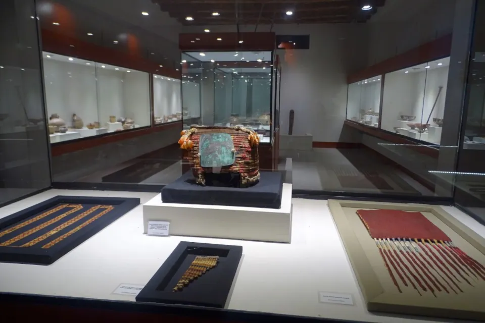
Antonini Archaeological Museum
This museum exhibits mummies, artifacts, ceramics, textiles and trophy heads found in Cahuachi, allowing you to understand the cultural richness of the Nazca.
It also offers information about the geography of the desert coast and the cultures that thrived there, with exclusive photographs of the geoglyphs.
- Av. La Cultura 600, Nazca.
- Admission fee: 20 soles
- Price for children and students: 7 soles
* Children under 5 years old are free of charge
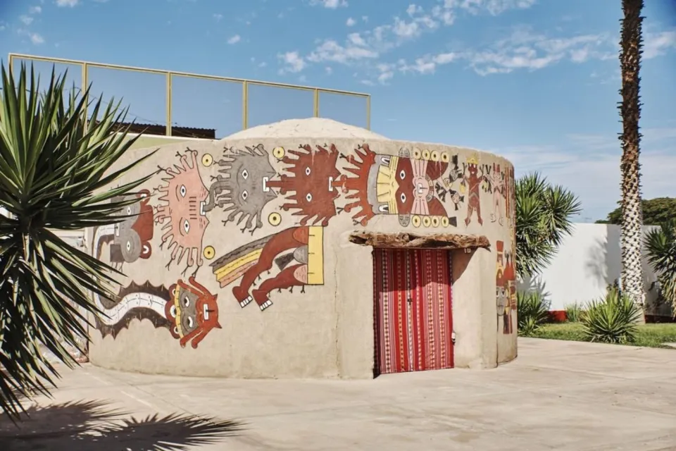
Nazca Planetarium
If you want to understand the relationship between the lines and astronomy, the Nazca Planetarium offers observation of stars, the moon and planets with modern telescopes and talks on Maria Reiche's theories and the possible astronomical use of the geoglyphs.
- It is located in Jr. Bolognesi, inside the city of Nazca.
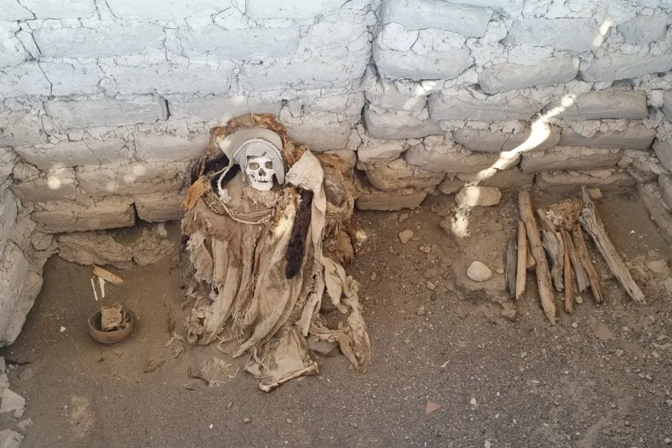
Chauchilla Cemetery
This site is a pre-Inca necropolis that preserves mummies and ancient remains in excellent condition thanks to the arid climate of the Nazca desert.
Although much of the site was looted, the mummies remain in their original tombs, which is unusual in Peru. This cemetery was used by various cultures, including the Wari, Poroma and even the Incas.
- It has been protected since 1990 and is 29 km from the Plaza de Armas of Nazca.
The Paredones
The Paredones are the remains of an Inca administrative complex built during the reign of Tupac Yupanqui on ancient Nazca ruins.
This site has a central plaza, administrative, residential and ceremonial buildings. Its walls combine adobe with stone, an uncommon style in traditional Inca architecture.
- Only 1.6 km from the Nazca Main Square.
Cerro Blanco
At 2,078 m a.s.l., Cerro Blanco is the highest dune in Peru and one of the highest in the world, ideal for sandboarding.
However, buggies cannot reach the top, so you will have to walk approximately three hours with boards to enjoy the descent.
- It is located 20 km from the city of Nazca.

Tips for a smooth flight over the Nazca Lines
If you plan to fly over the Nazca Lines, follow these tips to enjoy a safe, comfortable and memorable experience:
- Do your research and choose the right airline: Read flight reviews and select airlines with experienced pilots. They know how to fly at steep angles and make tight circles to give you the best views of the lines.
- Ask for information on aircraft maintenance: Ask the agency or airline for the maintenance report to travel with peace of mind.
- Take care of your diet before the flight: Eat something light at least two hours before the flight to avoid dizziness. Avoid consuming alcohol the night before.
- Avoid the flight if you suffer from chronic vertigo: Sudden movements and turbulence may cause nausea if you are prone to motion sickness.
- Carry airsickness patches or pills: Use them before boarding the plane to prevent discomfort. Plan ahead: In high season, hotels and tours sell out quickly, and last-minute bookings tend to be more expensive.
- Carry cash: You will need it if you want to buy souvenirs or handicrafts after the flight.
- Listen carefully to the pilot's and guide's indications: This way you will be able to better identify each figure during the flight.
- Wear light clothing: The weather in Nazca is usually warm, so wear comfortable and cool clothes.
- Don't forget your camera with a charged battery: The views are breathtaking and you will want to capture every moment.
- Bring water or hydrating drinks: The sun on the Peruvian coast is intense and it is important to stay hydrated.
- Keep your valuables in the hotel safe: Although Nazca is safe, it's always better to be safe.
- Explore the city with caution: If you walk around at night, use lighted and busy streets.
- Avoid buying tours or lodging from street vendors: They usually offer high prices near the bus terminal.
- Negotiate the price before taking a cab on the street: Some drivers charge higher fares to tourists if you do not agree on the price beforehand.
- Try the local food: Take the opportunity to enjoy a delicious fresh ceviche, typical of Peru's coastal areas.
Frequently Asked Questions
- How many Nazca Lines are there?
Currently, 800 straight lines, 300 geometric figures and 70 designs of animals and plants, known as biomorphs, have been identified. The Nazca people spread these geoglyphs throughout the pampas, showcasing the creativity and precision of their ancestral culture.
- Can I visit the lines without flying?
Yes, you can visit the Nazca lines without taking a flight, although the experience will be different.
You can see some figures from:
- The Nazca Lookout Tower, located next to the Panamericana Sur highway, where you can clearly see “The Tree”, “The Hands” and part of “The Lizard”.
- The natural hills surrounding the Nazca pampas, from where fragments of straight lines and some figures can be seen.
However, overflight is the only way to appreciate the full magnitude of these geoglyphs, since only from the air you will be able to observe the designs in their entirety.
- Are the Nazca Lines protected?
Yes, the Nazca Lines are protected as a World Heritage Site by UNESCO since 1994 and under the supervision of the Peruvian Ministry of Culture, which is in charge of their conservation and protection against damages and human activities that may affect them.
- To which culture do the Nazca lines belong?
The Nazca culture created the Nazca Lines while it developed between approximately 200 B.C. and 600 A.D. on the southern coast of Peru. However, some lines are older, so many researchers consider that the Paracas culture, the predecessor of the Nazca, could have created certain geoglyphs.
- Why does Google Earth allow us to see the Nazca Lines?
Maybe you have already tried to see the Nazca lines in Google Earth and only managed to distinguish some large figures. This happens because the Nazca did not carve the geoglyphs deep into the ground; instead, they removed the dark surface layer of stones to expose the lighter layer beneath.
This subtle contrast is difficult to capture clearly from a great distance, so only the larger, sharper figures are visible from Google Earth.
The Nazca Lines are a testament to the creativity, astronomical knowledge and connection to nature of ancient Peruvian cultures. This archaeological mystery continues to invite us to learn more about our history and to reflect on the legacy that civilizations leave on earth.
If you visit Peru, do not miss the opportunity to know and respect this unique place in the world.
